
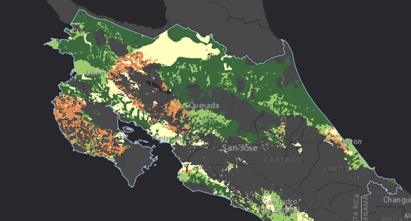
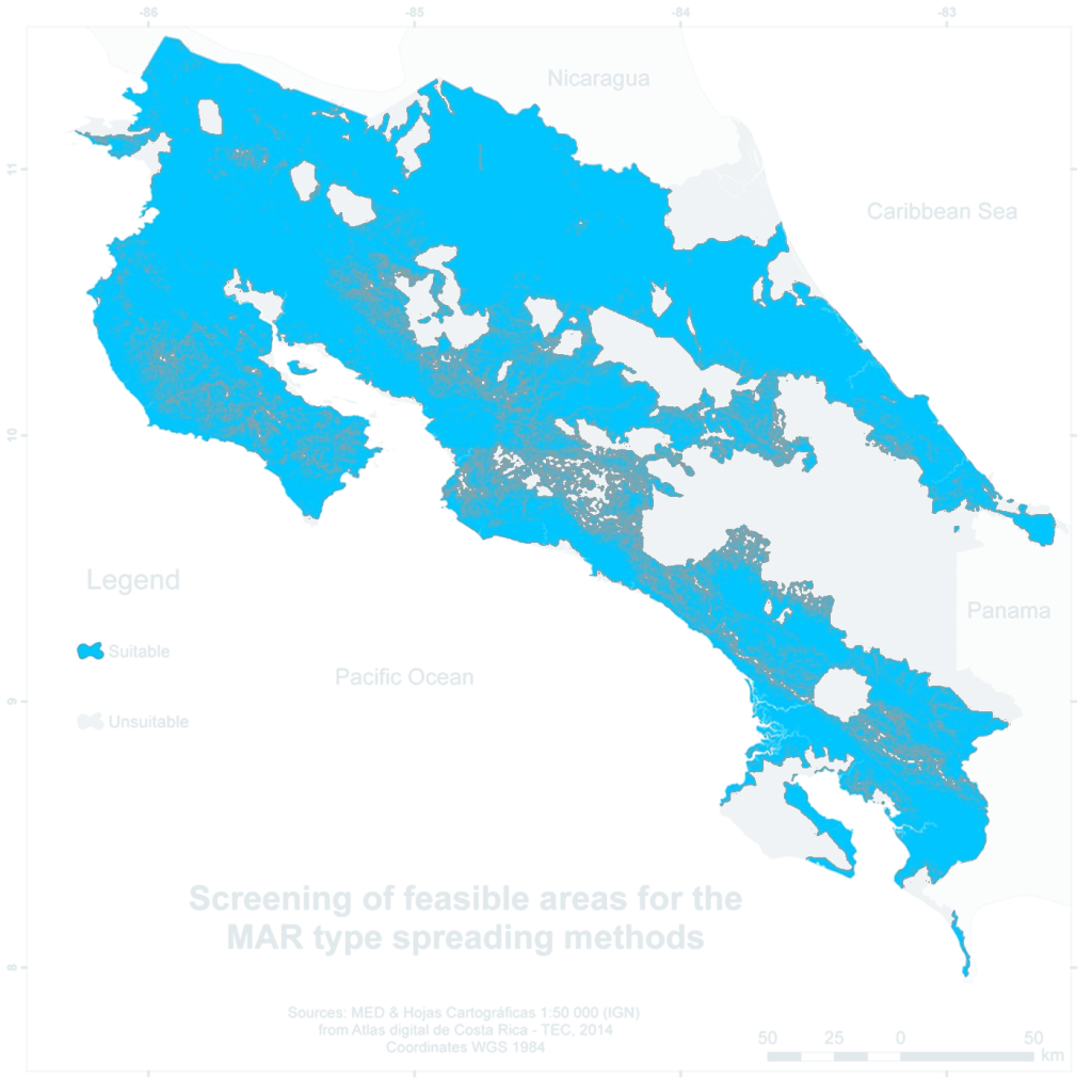
Costa Rica receives more than 3,300 mm of rain a year, yet the Pacific and Central regions have almost no rain for four months. A national GIS-MCDA identified where spreading methods could store wet-season water in unconfined aquifers. After screening, 61% of the country remained suitable, and 30% of the country ranked high or very high.
| Location | Costa Rica, whole country |
|---|---|
| Application | MAR site suitability, spreading methods |
| Study area | 51,100 km², working scale 1:500,000, WGS 84 |
| Criteria | 4 criteria; screening by slope, soil, protected areas, wetlands and beaches |
| Weighting | Multi-influencing factor (MIF); 8 sensitivity scenarios |
| Project | AyA (Costa Rican Institute of Aqueducts and Sewers) and Junior Research Group INOWAS, TU Dresden |
| Year | 2016 |
The question
About two-thirds of Costa Rica’s rainfall becomes runoff. Rivers in the Pacific watersheds are short and respond quickly to rain, so most wet-season water reaches the ocean. The dry season coincides with the tourist high season, when water supply systems are under the most pressure. Managed aquifer recharge (MAR) can store surplus water underground for the dry months.
The study asked which parts of the country have the best intrinsic conditions for spreading methods: infiltration ponds and basins that recharge an unconfined aquifer through permeable ground. It used only physical criteria, which change little over time. Land use, infrastructure, water sources and costs were left to later, site-specific studies. The result is the first national screening map for MAR in Costa Rica, showing where detailed investigations are worth starting.
Study area and data
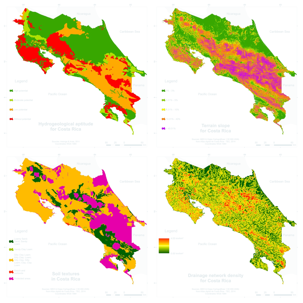
The analysis covers the whole country. Four thematic layers served as criteria. The hydrogeology and soil maps were only available at 1:500,000, which set the working scale of the final map.
- Hydrogeological aptitude: potential of a geological formation to hold an unconfined aquifer (high, moderate, low, without potential), after Astorga and Arias, based on the 1:500,000 geological map
- Terrain slope: 30 m digital elevation model from the Costa Rica Digital Atlas (TEC)
- Top soil texture: soil map of the Ministry of Agriculture (MAG) at 1:500,000, digitised by TEC
- Drainage network density: river network from the 1:50,000 topographic maps of the National Geographic Institute (IGN)
Two of the criteria also served for screening. Slopes above 40%, defined as steep terrain by the Forest Law, were excluded, as were protected areas, wetlands and beaches. More than a quarter of Costa Rica is under some form of protection, and the main cordilleras drop out for both reasons.
Each criterion was rescaled from 0 to 1. Hydrogeological aptitude and soil texture used step functions: sand, loamy sand and sandy loam scored 1.0, sandy clay loam 0.67, clay loam and loam 0.33, and clay and silty soils 0. Slope used linear segments with break points at 3, 5, 10 and 30%. Drainage density decreased linearly from 1.0 at 0 km/km² to 0 at the national maximum of 4.03 km/km².
Weighting
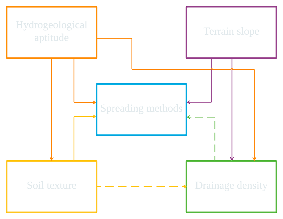
The weights come from the multi-influencing factor (MIF) method. A criterion receives 1 point for each major effect it has on another criterion or on recharge, and 0.5 points for each minor effect. Hydrogeology, for example, controls soil formation and the development of river networks, and it governs recharge directly. Six major and two minor effects add up to 7 points.
| Criterion | Score | Weight |
|---|---|---|
| Hydrogeological aptitude | 1 + 1 + 1 = 3 | 43% |
| Terrain slope | 1 + 1 = 2 | 29% |
| Soil texture | 1 + 0.5 = 1.5 | 21% |
| Drainage network density | 0.5 | 7% |
A weighted linear combination (WLC) then overlaid the four standardised layers within the screened area.
Results
61% of the country suitable after screening
30% of the country with high or very high suitability
6 of 8 sensitivity scenarios keep over 90% of the area in its class
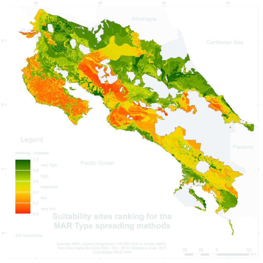
The suitability values were grouped into five classes of equal width. The high and very high classes cover almost half of the suitable area. They concentrate in the Northern and Tortuguero lowlands and along both banks of the Tempisque River in Guanacaste, the region with the most water scarcity problems in the previous decade. The Nicoya Peninsula and the General valley rank mostly low.
| Class | Score | Suitable area | Country area |
|---|---|---|---|
| Very high | 0.8–1.0 | 20.4% | 12.4% |
| High | 0.6–0.8 | 29.4% | 18.0% |
| Moderate | 0.4–0.6 | 22.2% | 13.5% |
| Low | 0.2–0.4 | 16.2% | 9.9% |
| Very low | 0.0–0.2 | 11.8% | 7.2% |
The sensitivity analysis built eight scenarios by adding or removing one minor or major effect in the MIF diagram. In six of them, more than 90% of the area kept its class. Removing a minor effect from soil texture changed the class of 29.4% of the area, about half of it from high to very high. Since the map points to areas worth investigating rather than excluding them, the authors judged this uncertainty acceptable.
The map is a base layer for decision makers. Water demand, available water sources and wastewater facilities can be added to prioritise sites, for example within a radius around production wells that need to increase their yield.
What we learned
- The coarsest layer sets the scale. Two national maps at 1:500,000 limited the whole analysis, regardless of the 30 m elevation model.
- An inclusive question tolerates upward shifts. The study looked for places to investigate, so a change from high to very high carries little risk.
- MIF weights are easy to explain. Each weight traces back to arrows in one diagram, and the sensitivity analysis changes one arrow at a time.
- Class labels need care. Formations rated “without potential” can still hold fractured aquifers, and some of the country’s most important supply aquifers lie in such formations.
Links
- Publication: Bonilla Valverde, J.P., Blank, C., Roidt, M., Schneider, L., Stefan, C. (2016). Application of a GIS multi-criteria decision analysis for the identification of intrinsic suitable sites in Costa Rica for the application of managed aquifer recharge (MAR) through spreading methods. Water 8(9), 391. doi:10.3390/w8090391
- Figures: reproduced from the article under the CC BY 4.0 licence
The same workflow runs in mcda.Studio. The screening layers become constraints, the MIF scores go into the multi-influence weighting method, and the eight scenarios correspond to the sensitivity step.